skip to main |
skip to sidebar

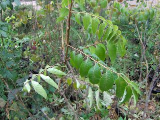
Väylien välissä ruusuangervoa (Spiraea japonica "Froebelii") 10.9.2007. Etummaiset on leikattu matalammaksi kesken kasvukauden - Japanese Spiraea (Spiraea japonica "Froebelii") between the paths at the 10th of September 2007. The foremost ones have been cut down lower in the middle of the growing season.
 Tuoksuvatukkaa (Rubus odoratus) typistettynä 11.9.2007 - Flowering Raspberry (Rubus odoratus) as pruned down at the 11th of September 2007.Olen tänäkin vuonna vieraillut ahkerasti muutamassa paikassa täällä pääkaupunkiseudulla tekemässä kasvivalokuvausprojektiani. Samalla olen kiinnittänyt huomiota mm. kasvien käyttöön viheralueilla ja pihoilla. Olen löytänyt siitä edelleen kritisoitavaa. Useita satoja kasvilajeja erinomaisesti ja läpikotaisin lähinnä itse oppineena olen herkkä havainnoimaan erilaisia puutteita, mutta tässä esitettävällä asialla on myös käytännön merkitystä huomattavasti.Yllä oleva kuvapari on kuvattu Espoon Tapiolassa ja siinä nähdään tämänkertainen aihe; kasvien kasvutapojen väärinhahmottamisen takia vääränlaisiin paikkoihin istutetut kasvit ja siitä johtuvat väärät "hoitotavat" (tilanne luo ko. hoitotarpeet lähtökohtaisesti väärin perustein). Alemmassa kuvassa on tuoksuvatukkaa kerrostalon seinustalla pienen hiekkakäytävän ollessa sen edessä. Kasvia täytyi leikata, koska sen oksat olivat kasvaneet liikaa käytävän puolelle. Ahtaudesta seuraa "tarpeetonta" leikkaamista ja kasvin esteettinen olemus häiriintyy. Ylemmässä kuvassa kadun ja kevyenliikenteen väylän välissä on ruusuangervoa. Kohdalla olevan risteysalueen takia tuota osaa pensaista täytyi madaltaa, jotta näkyvyys ei olisi huono tielle autoista. Liian korkeaksi kasvava pensas kohtaa kohdalla "tarpeetonta" joka vuotista leikkuustressiä ja esteettinen voima vähenee. Esimerkkejä löytyy runsaasti puidenkin joukosta ympäri Etelä-Suomea; liian ahtaassa kasvavista puista täytyy katkoa oksia tai niitä typistetään voimakkaasti. Äärimmäisenä esimerkkinä on rungon katkaiseminen tapille "nuorentamisen" nimissä. Jälleen seurauksena on lajille tyypillisen esteettisen arvon väheneminen tai jopa sen menettäminen. Puiden tapauksessa tarpeettomalla leikkaamisella ja typistämisellä on myös puun terveyttä heikentävä vaikutus. Puut saavat helpommin sienitauteja ja ne lahoavat vanhemmiten nopeammin kuin muutoin. Sopusoinnussa puun kanssa olevat hoitoleikkaukset ovat asia erikseen.Kasveja istutettaessa on aina ajateltava myös sitä, kuinka isoksi ko. laji lopulta kasvaa ja sitten se täytyy sijoittaa sen myötä oikean kokoiseen paikkaan. Näin vältetään tarpeettomat leikkaamiset tulevina vuosina. Esim. Etelä-Suomen yksityisillä pihoilla tällaista kasvuahtautta näkee melko yleisesti. Se on ymmärrettävää, jos ei ole vaivautunut / ehtinyt opettelemaan kasvien ominaisuuksia tai ei omaa kunnolla avaruudellista hahmottamiskykyä. Mutta hyvän puutarhakulttuurin kehittämisen kannalta kasvien ominaisuuksiin tutustuminen on välttämätöntä. Välillä näitä ahtaus- ja liikakasvuvirheitä näkee myös julkisilla viheralueilla, kuten yllä. Se on monta astetta nolompi asia, koska kyseessä ovat sentään asiantuntijoiden tekemät suunnitelmat ja toteutukset. Luulisi ainakin heidän tietävän.Voidaankin kysyä, mistä jopa sellainen virheellisyys johtuu? Tutkin asiaa n. tunnin verran sieltä, mistä tiesin löytyvän ainakin yhden selvän vastauksen; kasvikirjoissa, -oppaissa ja puutarhakauppojen myyntilistoissa olevat kasvilajikuvaukset. Olen jo vuosia sitten havainnut sen, että esim. tällaiset lajikuvaukset antavat liian usein alimitoitettuja kasvukorkeuksia. Jopa alan raamattuna pidettävässä kirjassa Suomen puu- ja pensaskasvio on jonkin verran tätä ongelmaa. Tämä on yksi lähtökohtainen syy sille, että kasveja ajatellaan liian pieniksi ja sen takia istutuksia ollaan laittamassa liian ahtaisiin paikkoihin. Tämä koskee myös liian lähelle toisia puita istutettuja puita.Tässä on esimerkkejä Harvialalta: Puut; rusokirsikka (Prunus sargentii) 3 - 5 m - laji saavuttaa usein 10m:n rajan. Isot pensaat / pienet puut; mongolianvaahtera (Acer tataricum ssp. ginnala) 3 - 5 m - tämä on aivan liian vähän, sillä laji saavuttaa lähes aina yli 5 m korkeuden myös monirunkoisena. Sirotuomipihlaja (Amelanchier laevis) 3 - 4 m - laji kasvaa oikeasti lähes aina yli 5m korkeaksi. Pähkinäpensas (Corylus avellana) 2 - 4 m - aliarvioitu, sillä pensas kasvaa n. 5 m korkeaksi. Pienet pensaat; norjanangervo (Spiraea "Grefsheim") 1 - 1,5 m - pensas kasvaa oikeasti n. 2 m korkeaksi. Ruusuangervo (Spiraea japonica "Froebelii") 0,5 - 1 m - lajike kasvaa oikeasti 1 - 1,5 m korkeaksi.Sitten esimerkkejä Muhevaiselta; Puut; hurmevaahtera (Acer platanoides "Faassen's Black") 8 - 14 m - kasvaa käytännössä lähes metsävaahteran (Acer platanoides) kokoiseksi eli lähenee 20m:ä vanhana. Kotipihlaja (Sorbus aucuparia) 4 - 12 m - pienin lukema on liian vähän, sillä puu kasvaa karuhkossakin paikassa usein yli 5 m korkeaksi. Isot pensaat / pienet puut; kultasade (Laburnum alpinum) 3 - 5 m - kasvaa hyvällä paikalla aina yli 5 m. Mustaselja (Sambucus nigra) 2 - 3 m - tämä kasvaa usein 5 m tienoille ja ylikin. Pienet pensaat; kultaherukka (Ribes aureum) 1 - 1,5 m - pensas saavuttaa lähes aina 2 m. Esimerkkejä olisi useita lisää ja eteläisen Suomen olosuhteisiin nähden nuo suurimmatkin korkeudet ovat alimitoitettuja. Myös kasvin kasvutavasta käytettävä harhaanjohtava nimitys voi aiheuttaa lajin istuttamista liian ahtaaseen paikkaan; rusotuomea (Prunus virginiana "Schubert") kutsutaan pensaaksi Muhevaisen listassa, vaikka kyseessä on helposti paljon yli 5m korkeaksi kasvava puu. Sen takia lajin ostaja ja käyttäjä kuvittelee puun pienemmäksi kuin se todellisuudessa on. Pensaiden kohdalla myös kasvuleveys on tärkeä asia, joka tulisi ilmoittaa lajikuvauksissa. Tässäkään ei usein osata arvioida kunkin lajin tarvitsemaa kasvuleveyttä. Niinpä pensaat istutetaan esim. liian lähelle kulkuväyliä tai liian kapeaan paikkaan, kuten yllä talon seinustalla. Tällöin pensaita joudutaan leikkaamaan jopa joka vuosi kulkuväylien sivuilta. On valittava laji ja istutusten rajaus oikein tai jätettävä istutettava alue riittävän isoksi muun suunnittelun ja toteutuksen yhteydessä.Ei ihme, jos kasveja istutetaan usein liian ahtaaseen tai niistä tulee toivottua korkeampia, kun lajikuvauksista paljastuu näin paljon virheellistä tietoa kasvien käyttöä varten jo tunnin silmäilyn jälkeen. On noissa kuvauksissa ok tietoakin kasvukorkeuksista, mutta tällainen leväperäisyys tuntuu minusta kummalliselta ja epäammattimaiselta. Se vaatii korjaamista ja se antaa minulle yhä enemmän syytä tarjota parempaa vaihtoehtoista tietoa kasveista myös tässä mielessä. Vääristä kasvutiedoista aiheutuvat tarpeettomat hoitotoimet ovat myös rahan ja energian tuhlausta ja se on silloin pois tärkeämmistä puistoihin ja puutarhoihin liittyvistä hoito- ym. toimenpiteistä. Esteettisyys on erittäin tärkeää kasvisuunnittelussa, mutta niin on myös käytännöllisyys. Ilmastonmuutos täytyy huomioida jälleen kerran myös tämän asian yhteydessä. Sen takia monet lajit voivat jo lähitulevaisuudessa kasvaa aikaisempia määrityksiä paljon paremmin = isommiksi. Tämä koskee etenkin aikaisemmin enemmän tai vähemmän talvenarkoina pidettyjä lajeja. Esim. jumaltenpuu (Ailanthus altissima) ja valeakaasia (Robinia pseudoacacia) tulevat todennäköisesti jo n. 10 vuoden kuluessa saamaan mahdollisuuden kasvaa monin paikoin helposti pieniksi puiksi (jopa yli 10 m) etelärannikolla, vaikka vanhojen (jopa yli 20 vuotta sitten tehdyt) määritelmien mukaan niistä ei voisi odottaa alle 5 m pensasta enempää, jos sitäkään. Nämä viime vuodet ovat jo osaksi osoittaneet tämän esim. Helsingin Kaisaniemen kasvitieteellisessä puutarhassa; jopa melko kylmällä ja varjoisalla kasvupaikalla samettisumakki (Rhus hirta) ja neidonhiuspuu (Ginkgo biloba) ovat kasvaneet siellä n. 5m korkeiksi pikkupuiksi viimeisten n. 5 vuoden aikana. Niinpä jo nyt istutettavia ns. talvenarkoja lajeja täytyy arvioida ja kuvitella tulevaisuuden ilmaston lähtökohdista ja valita riittävän tilava kasvupaikka varmuuden vuoksi. Muutoin voidaan joutua tarpeettomaan leikkaamisen ja typistämisen kierteeseen ja ko. lajin esteettiset ominaisuudet ja mahdollisuudet tulee samalla jopa hukattua. Sama voi koskea jo aikaisemminkin hyvin menestyneitä lajeja. Tulevaisuudessa monet niistä saattavat menestyä jopa entistäkin paremmin. Joidenkin vointi saattaa tosin heikentyäkin.I have visited frequently in a few places here in the capital city area during this year as well to do my plant photography project. At the same time I have payed attention for example to the use of plants on green areas and yards. I have found further things to criticize on that. As I have learned mainly by myself several hundreds of plant species excellently and thoroughly I am sensitive to observe many kinds of shortcomings, but the case displayed here has also significant practical meaning.The upper pair of photos is taken in the district of Tapiola in Espoo and in there we see the matter of this case; plants being planted into wrong kinds of localitys due to a wrongly perceived growth habits of the plants and the wrong "maintenance" / "caring" methods caused by that (the situtation creates the caring / maintenance needs originally on wrong basis). In the lower photo there is Flowering Raspberry at the wall of an apartment building as a small pavement is in front of that. The plant had to be cut, because its shoots were grown too much in the side of the pavement. The lack of space causes "unnecessary" cutting and the esthetic value of the plant decreases. In the upper photo there is Japanese Spiraea between the street and the pedestrian pavement. Due to the crossing on the spot that part of the shrubs had to be lowered down due to the fact, that there wouldn't be a bad view to the street from cars. The shrub on the spot faces "unnecessary" cutting stress yearly and the esthetic power decreases.There are found examples a lot around southern Finland concerning trees as well; from the trees growing in too narrow places twigs had to be cut or they are pruned strongly. As an extreme example there is a trunk being pollarded in the name of "rejuvenating". Again the result is a decreasing of the esthetic value typical of the species or even losing it. In the cases of the trees the unnecessary cutting and pruning has a weakening effect to the well being of a tree. The trees get fungus diseases more easily and they will decay faster at an old age than othervise. The maintenance cuttings in harmony with the trees are a different story.When planting plants one have to always think about also the fact, that how big the species in question will grow eventually and then due to that it must be placed on a right sized place. In this way one can avoid unnecessary cuttings during following years. For example in the private yards of southern Finland this kind of lack of space is seen rather commonly. It is understandible, if one hasn't been interested or hadn't had time to learn properties of the plants or one doesn't have a proper ability to visualize spatially. But in regard of developing a good horticulture, getting to know plant's properties is necessary. Occasionally these errors of narrowness and over growth are seen even in public green areas, like above. It is several degrees more of an embarrasing matter, because here are in question plans / designs and realizations made by experts. One would think, that at least they should know.One can ask therefore, that what causes even these kinds of errors? I expolred the matter for about an hour from there, where I knew I can find at least one clear answer; plant species describtions in plant books, plant quides and garden shops plant lists. I have noticed allready several years ago, that for example these kinds of species describtions give too often underrated growth heights. Even in the book considered as the bible of the profession (in Finland) Suomen puu- ja pensaskasvio (Flora of Finland's trees and shrubs) has somewhat of this problem. This is one original reason for the fact, that plants are being considered too small and therefore plantings are being placed into too narrow places. This applies also to the trees planted too close to other trees.Here are examples from Harviala (unfortunately not in english): Trees; Sargent Cherry (Prunus sargentii) 3 - 5 m - the species will reach often the limit of 10 m. Large shrubs / small trees; Amur Maple (Acer tataricum ssp. ginnala) 3 - 5 m - this is way too little, because the species will reach allmost always more than 5 m also as in multistemmed condition. Allegheny Serviceberry (Amelanchier laevis) 3 - 4 m - this species grows actually more than 5 m high allmost always. European Hazel (Corylus avellana) 2 - 4 m - underrated, because the species will grow about 5m high. Small shrubs; Grefsheim Spiraea (Spiraea "Grefsheim") 1 - 1,5 m - the shrub will grow actually about 2 m high. Japanese Spiraea (Spiraea japonica "Froebelii") 0,5 - 1 m - the cultivar will grow actually 1 - 1,5 m high.Then examples from Muhevainen (unfortunately not in english): Trees; Faassen's Black Norway Maple (Acer platanoides "Faassen's Black") 8 - 14 m - will grow practically allmost as high as Norway Maple (Acer platanoides) at an old age. In other words will be nearing 20 m of height. European Mountain Ash / Rowan (Sorbus aucuparia) 4 - 12 m - the smallest figure is too little, because the tree will grow even on a rather poor place often more than 5 m high. Large shrubs and small trees; Scotch Laburnum (Laburnum alpinum) 3 - 5 m - will grow on a good place always more than 5 m high. Elderberry (Sambucus nigra) 2 - 3 m - this will grow often about 5 m high and more as well. Small shrubs; Buffalo Currant (Ribes aureum) 1 - 1,5 m - The shrub will reach allmost always the limit of 2 m. There would be several examples more and viewed against the circumstances of southern Finland even those highest figures are underrated.Also a misleading term used of the plant's growth habit can cause planting of a plant into too narrow space; Shubert Chokecherry (Prunus virginiana "Schubert") is called as a shrub in the list of Muhevainen, allthougt in question here is a tree growing easily much more than 5m high. That is why the buyer and the user of the tree is imagining the tree to be smaller than it actually is. In the cases of shrubs a growth width is also important, which should be given in the species describtions. In here as well one cannot many times evaluate the width of space needed by every plant. Therefore shurbs are being planted for example too close to paths and into too narrow spaces, like above at the wall of the building. Therefore shrubs are being forced to cut from the sides of the paths even yearly. One must choose the species and the lining of the plantation right or the planted area must be kept large enough at the same time with other planning and realization.It is no wonder, if plants are being planted often into too narrow places or they become higher than wished for, as there was revealed so much errors in the species descriptions for plant usage after only an hour long looking through. Those species description do have ok information as well about the growth heights, but this kind of negligence feels peculiar and unprofessional to me. That requires correcting and it gives me ever more reasons to give better alternative knowlege about the plants in this regard as well. The unnecessary maintenance / caring tasks caused by the wrong growth information are a waste of money and energy as well and it is then away from the more important maintenance and other tasks associating with parks and gardens. Esthetic matters are very important in the plant planning / designing, but so are practical matters as well.The climate change must be counted for once again with this matter as well. Due to that many species can grow much better = bigger allready in the near future. This applies especially to the species considered earlier as more or less winter sensitive (not so hardy). For example Tree-of-heaven (Ailanthus altissima) and Black Locust (Robinia pseudoacacia) will have propably in about 10 years time a possibility to grow in many places by the southern coast as little trees (even more than 10 metres), allthough according to old definitions (made even more than 20 years ago) one wouldn't expect from them any more than just a shrub under 5 metres high, if even that.These last few years have allready pointed that out partially for example at the botanical garden of Kaisaniemi in Helsinki; even at a rather cold and shadowy locality Staghorn Sumac (Rhus hirta) and Maidenhartree (Ginkgo biloba) have been grown there into about 5 m high little trees during last about 5 years. Therefore the so called winter sensitive species planted allready now must be estimated and imagined from the basis of the future climate and choose a spacious enough growing place to be sure. Othervise one can be forced to a cycle of an unnecessary cutting and pruning and the properties and possibilities of the species in question will be even wasted at the same time. The same can apply to the species grown well allready earlier as well. In the future many of them might grow even better than before. Though, a well being of some species might get worse as well.
Päättynyt viikko oli koko Suomessa hyvin leuto ja leutous korostui etenkin Lapissa. Etelä-Suomen säätä viilensi aluksi korkeapaine, kuten aikaisemmin kerroin. Nyt muutaman päivän ajan lämpötilat ovat olleet käytännössä Lappia myöten +5 ja +10 asteen välillä koko ajan ympäri vuorokauden. Tällaiset lämpötilat ovat Pohjois-Suomessa erittäin korkeita tähän aikaan vuodesta, kun siellä pitäisi olla normaalisti jo talvi. Tämä näkyy nyt esim. Euroopan lumivarmimmaksi mainostetussa laskettelukeskuksessa Kuusamon Rukalla. Tänään he ovat joutuneet sulkemaan ainoan tykkilumella aikaisemmin valmiiksi saadun rinteen liiallisen sulamisen takia. Näin heille ei ole tykkilumien aikakaudella koskaan ennen käynyt. Ei edes viime vuonna erittäin leutona syksynä. Luonnonlunta Lapissa ei ole edelleen ollenkaan; se näkyy hyvin kelikameroista. Nämäkin ovat ilmastonmuutoksen oireita.Täällä Etelä-Suomessa leutous on vaikuttanut mm. siihen, miten kasvukauden loppuminen määritellään. Käytössäni ei ole omia tarkkoja lämpötilahavaintoja määritelmien pohjiksi, mutta määritelmä kasvukauden päättymisestä saattoi toteutua etelärannikollakin tuon kylmän korkeapaineen takia; vuorokauden keskilämpötilat vähintään 5 vuorokautta peräkkäin alle +5 astetta. Toisaalta keskilämpötilat ovat olleet nyt uudestaan yli +5 astetta yli 5 päivää peräkkäin etenkin etelärannikolla ja siis jopa osassa Lappia. Lokakuun säätilaston (Helsingin Puistolan sääasemalta) ilmestyttyä voimme tarkastella asiaa paremmin etelärannikon osalta.Viime viikon aikana eteläisessä Suomessa olleet ruskan vaiheet etenivät nopeasti kohti loppua kahden seikan auttamana. Yhtäältä leudoksi palannut sää edisti viimeisten lehtivihreiden virtaamista lehdistä pois. Tällöin ruskavärejä ilmaantui vielä paikoin näyttävästi etenkin etelärannikon taajamissa. Toisaalta kahden edellisen päivän aikana voimistuneet lounaistuulet ovat riipineet tehokkaasti näitä viimeisiä lehtiä puista ja pensaita. Sisämaassa lehtipuut ovat alastomia lukuunottamatta yksittäisiä paikallisia tapauksia. Etelärannikon taajamissa on edelleen siellä täällä melko runsaastikin lehteviä ja osittain jopa vihreitä puita ja pensaita, mutta selvästi suurin osa lehdistä on jo varissut täälläkin.Tällä viikolla lehtien variseminen jatkuu tehokkaana, koska sää jatkuu ajoittain tuulisena ja keskiviikkoon asti jatkuva hyvin leuto sää edistää ruskan etenemistä viimeisissä vihreissä lehdissä. Keskiviikon jälkeen sää näyttää kylmenevän, kun voimakas matalapaine ylittää Suomen torstaina itään ja se tuo jäljessään kylmät luoteistuulet. Lämpötilat tippuvat viikonlopuksi alle +5 asteen ja pakkasen vaara kasvaa riippuen tuulisuudesta ja pilvisyydestä. Tämän takia ruskan eteneminen pysähtyy taas liiallisen kylmyyden takia; lehtivihreän virtaaminen pois lehdistä vaatii yli +5 asteen vuorokausikeskilämpötiloja, kuten kasvien muutkin elintoiminnot. Jos viikonlopusta alkaa jopa pakkasjakso, niin se tietää viimeisten vihreiden lehtien kuivumista ja ne varisevat sitten ilman varsinaista ruskaa. Tässä vaiheessa on vaikea arvioida tulevan kylmän jakson voimakkuutta ja pituutta, mutta nyt etelärannikollekin saattaa tulla ensimmäinen kunnollinen maistiainen talvesta ja sen myötä mahdollisesti satava lumi ja maan jäätyminen keskeyttävät monet puisto- ja puutarhatyöt. Arboretumini ja taimistoni osalta silloin minun olisi hyväksyttävä talvitauon alkaminen kokonaan...Päivitys 30.10.2007 klo. 23:00: Viimeisimmät sääennusteet kertovat, että huomisen matalapaineen jälkeen lauantaiksi lännestä saapuva uusi matalapaine tuo talven makua myös etelärannikolle. Matalapaine liikkuu Suomen eteläosien yli itään ja sateet tulevat ainakin osittain lumena koko Etelä-Suomessa lämpötilojen ollessa lähellä nollaa. Sitten sunnuntaina vallitsevat kylmät pohjois-koillistuulet pitävät lämpötilat päivälläkin ainakin sisämaassa asteen pari pakkasen puolella. Seuraavan viikon alussa lännestä näyttää tulevan uusia matalapaineita, mutta kylmä ilmamassa ei ehkä anna periksi vähään aikaan ja siirry idemmäksi; yöpakkasia jopa -5 ja -10 asteen välillä ja mahdolliset sateet edelleen ainakin sisämaassa lumena... Näin istutuskausi päättyy ainakin joksikin ajaksi, kun maa alkaa jäätyä lauantaista eteenpäin ja lumipeite alkaa haittaamaan; jo lauantaina saattaa tulla useita senttejä.The ended week was very mild in whole Finland and the mildness was emphazised especially in Lapland. The high pressure cooled down the weather in southern Finland at first, as I told earlier. Now for a few days temperatures have been practically all the way in Lapland as well between +5 C and +10 C all the time night and day. These kinds of temperatures are very high in northern Finland at this time of the year, as there should be normally winter allready. This shows for example at the skicenter of Ruka in Kuusamo advertized as the most snow proof in Europe. Today due to a too much of melting they were forced to close the only slope that was finished earlier with the aid of a made snow. This hasn't happened never before to them in the era of the made snow. Not even last year during the very mild autumn. There isn't further natural snow in Lapland at all; it is seen well from the weather cameras. These are as well symptoms of the climate change.Here in southern Finland the mild weather has affected for example to the fact, how the ending of the growing season is determined. I don't have in my use precise temperature observations of my own for the basis of definitions, but the definition of the growing season's end might have been came true during that cold high pressure; the daily average temperatures at least 5 days in a row under +5 C. On the other hand the average temperatures have now been again over +5 C more than 5 days in a row especially by the southern coast and in that way even in parts of Lapland. As the weather chart of October is published (from the weather station of Puistola in Helsinki), then we can observe the matter better in the case of the southern coast.During the last week the phases of fall colours in southern Finland proceeded fast towards the end with the aid of two matters. Firstly the weather returned mild helped the last chlorophyls to stream away from the leaves. Therefore there appeared further locally showy fall colour tones especially at build areas of southern coast. Secondly southwesterly winds strengthened during the last couple of days have been ripping off these last leaves effectively from the trees and shrubs. In inland areas broadleave trees are naked not counted for single local cases. At southern coast's build areas there are yet rather foliage heavy and even partly green trees and shrubs here and there, but clearly most of the leaves have been fallen in here as well.During this week the shedding of the leaves will continue in an effective way, because the weather will continue occasionally windy and the very mild weather continuing up to wednesday will help fall colours to proceed in the last green leaves. After wednesday the weather appears to get colder, as a strong low pressure will cross Finland at thursday to the east and it will bring cold northwesterly winds behind it.Temperatures will drop under +5 C for the weekend and a risk for frost will increase depending on wind conditions and cloudiness. Due to this the proceeding of the fall colours will stop again because of too cold conditions; the chlorophyl streaming away from the leaves requires daily average temperatures over +5 C as do the other vital functions of the plants as well. If there will start even a frosty period from the weekend onwards, then it will mean drying of the last green leaves and then they will drop without actual fall colours.At this phase it is hard to estimate the severity and longevity of the coming cold period, but now there might come the first proper taster of the winter also to the southern coast and along with that a possible fallen snow and freezing of the soil will interrupt many park and garden tasks. Regarding my arboretum and nursery then I would have to accept the winter pause to start completely...Update at the 30th of October 2007 at 11:00 PM: The latest forecasts are telling, that a new low pressure arriving from the west until saturday after the tomorrow's low pressure will bring a taste of winter also to the southern coast as well. The low pressure will move across southern Finland to the east and the precipitation will come at least partly as snow in whole southern Finland, as temperatures will be around zero C. Then in sunday cold northerly-northeasterly winds will keep temperatures at least in inland areas couple of degrees freezing also during the afternoon. During the early part of the next week there seems to be coming new low pressures from the west, but the cold air mass doesn't perhaps give in for some time and move more eastwards; night frosts between even -5 C and -10 C and possible precipitation at least in inland areas further as snow... So the planting season will stop at least for some period of time, as the soil will start to freeze from saturday onwards and a snowcover will start to cause harm; there might come several centimetres allready during saturday.
Uudistin nyt blogitrilogiaa yhtenäisemmäksi kokonaisuudeksi. Keskusblogin osan ottaa Maisema - Landscape blogi. Muut blogit (Taivaankansi - Firmament ja Maan povi - The Bosom Of The Earth) ovat lisätietoa antavia sivublogeja. Niiden yksittäiset merkinnät ovat lokakuun 2006 alusta lähtien linkitetty tuon keskusblogin merkintöjen sekaan. Linkitysmetodina on kronologinen järjestys ko. blogien aikojen mukaan. Jätin syyskuun 2006 merkinnät ennalleen; jätän sen jakson muistoksi blogitrilogian kehitysvaiheista. Jatkossa blogitrilogian päivitykseen jää viive. Ehkä jätän sen noin vuoden mittaiseksi tai kavennan sitä innostuksen sattuessa ja ajan salliessa.I renewed now the blog trilogy into a more even whole. The blog Maisema - Landscape is taking a role of a central blog. Other blogs (Taivaankansi - Firmament and Maan povi - The Bosom Of The Earth) are side blogs giving extra information. Their single posts are linked among the posts of that central blog from October 2006 onwards. The linking method will be a chronological order according to the times of the blogs in question. I left the posts of September 2006 entact; I leave that period as a recollection of the blog trilogy's development phases. In the future there will be left a delay in the blog trilogy's updating. Perhaps I will leave it about a year long or I will make it more narrow as an enthusiasm occurs and time lets me.
Nyt olen päivittänyt blogitrilogian blogit Taivaankansi - Firmament ja Maan povi - The Bosom Of The Earth. Päivitetty jakso on 1. - 15. lokakuuta 2006. Pian jatkossa teen nämä blogit paremmin toimivaksi kokonaisuudeksi Maisema - Landscape blogin kanssa. Sen takia tein noiden kahden tekstit nyt hieman uudella tavalla; mahdollisimman lyhytsanaisesti. (Pinserin blogilistaa lukeville tiedoksi; blogitrilogiani blogit päivittyvät listan mukaan usein, vaikka en ole julkaissut blogeissa mitään uutta. Se johtuu blogeissani usein tekemistäni luonnosmerkinnöistä, jotka julkaisen vasta riittävän säätämisen jälkeen. Blogien sivuilla olevat päivitysmainostaulut ilmoittavat varsinaiset uudet julkaistut merkinnät.)Now I have updated the blog trilogy blogs Taivaankansi - Firmament and Maan povi - The Bosom Of The Earth. The updated period is between the 1st and the 15th of October 2006. Soon in the future I will make these blogs to be a better functioning whole with the blog Maisema - Landscape. Due to that I made the texts of those two now in a bit new way; as few words as possible.
Lokakuun 2007 blogitrilogian kuvasarjat täydentyvät taas Flickr -sivuillani. Täydennetty jakso kattaa ajan 16. päivästä 21. päivän iltaan asti. Tässä ovat linkit ko. sarjoihin; blogi 1, blogi 2 ja blogi 3.The blog trilogy photo sets of October 2007 are added again on my Flickr pages. The added period is from the 16th day up to the 21st day's evening. Here are the links to the sets in question; the blog 1, the blog 2 and the blog 3.
Tähän väliin mielenkiintoisesta säätilanteesta. Nyt on selvinnyt, että korkeapaine vaikuttaa Etelä-Suomen yölämpötiloihin erittäin voimakkaasti pilvisyyden mukaan. Suomen kaakkoiskulmalle on jäänyt pariksi päiväksi selkeän ja tyynen sään alue, jossa yöpakkaset pääsivät kiristymään sisämaassa viime yönä jopa -5 ja -10 asteen välille ja rannikollakin paikoin lähelle -5 astetta. Samalla vähän lännempänä (ja pohjoisempana) oli vähän lounaistuulta ja runsaasti pilviä, missä yölämpötilat pysyivät nollan yläpuolella. Erot näiden alueiden väleillä olivat jyrkät lyhyellä matkalla; esim. Hämeenlinnan ja Lahden välillä tämä havaitaan selvästi. Eroa näkyi myös vielä suhteellisen lämpimän meren vaikutuksen voimassa; Helsingin Kaisaniemen ja Helsinki-Vantaan lentokentän välillä se kävi ilmi hyvin, kun ensinmainitulla alueella lämpötila kohosi ensimmäisenä yhtäkkiä monta astetta sään selkeydestä huolimatta, kun tuuli virisi vähän mereltä. Tälläinen korkeapainetilanne ei välttämättä tiedä lämmintä säätä joka alueelle enää näin myöhään syksyllä, vaikka kesällä tämän tyyppinen sää tietää hellettä. Selkeiden alueiden maaperään on tämän takia muodostunut nyt ensimmäiset routakerrokset; alle 5 cm. Jatkossa sää näyttää kuitenkin muuttuvan leudommaksi myös öisin huolimatta vain vähäisestä pilvistymisestä.Päivitys 23.10.2007 klo. 9:50: Eilinen tilanne toistui tänä yönä ja aamuna lähes täysin samanlaisena. Yöpakkasta oli vain pienellä alueella kaakkoisessa Suomessa ja muualla oli läpi yön leutoa pilvien ja lounais-länsituulten ansiosta. Lapissa näin leuto sää (lämpötilat laajasti yli +5 astetta) on ajankohtaan nähden huomattavaa. Tämä erikoisen voimakas käänteinen (etelässä selvästi kylmempää kuin pohjoisessa) lämpötilajakauma näyttää edelleen loppuvan vähitellen viikon mittaan, kun kaakkoiseenkin Suomeen alkavat vaikuttaa leudot tuulet.Into this space about the interesting weather situation. Now it has been revealed, that the high pressure is influencing very strongly to the night temperatures of southern Finland according to cloudiness. There has been settled a clear and calm weather area for a couple of days at the southeastern corner of Finland, where the night forsts dropped last night in inland areas even between -5 C and -10 C and by the coast as well locally near -5 C. At the same time a bit westwards (and northwards) there were a bit of southwesterly winds and a lot of clouds, where the night temperatures remained above zero C.Differences between these areas were large in short distances; for example between Hämeenlinna and Lahti this is observed clearly. There was observed a difference also in the force of the warming effect of the relatively warm sea; that was revealed well between Helsinki Kaisaniemi ja Helsinki-Vantaa airport, as despite the clear weather the temperature rose suddenly several degrees the first at the firstly mentioned place, as winds picked up a bit from the sea. This kind of high pressure situation doesn't mean necessarily warm weather into all areas so late in the autumn anymore, allthough in summer this kind of weather type means a heatwave. Therefore now there have been forming the first layers of soil frost (under 5 centimetres) onto grounds of the areas with clear weather. However in the future the weather appears to become milder also at nights despite the weather being turned only a bit cloudier.Update at the 23rd of October 2007 at 9:50 AM: Yesterday's situation was repeated allmost completely in the same way during this night and morning. There was night frost only in a small area in southeastern Finland and elsewhere there was mild through the night thanks to clouds and southwesterly - westerly winds. In Lapland such a mild weather (temperatures above +5 C in a wide area) is significant considering the time of the year. This peculiarly strong reverse (clearly colder in the south than in the north) temperature distribution will be further appearing to end cradually during the week, as mild winds will be affecting also to southeastern Finland.
 Mustaselja - Elderberry (Sambucus nigra)
 Valeakaasia - Black Locust (Robinia pseudoacacia)
 Tuohituomi - Amur Chokecherry (Prunus maackii)
 Karvashikkori - Bitternut Hickory (Carya cordiformis)
 Kaljukultasade - Scotch Laburnum (Laburnum alpinum)
 Hirven katkaisema pilvikirsikka (Prunus pennsylvanica) - Fire Cherry (Prunus pennsylvanica) broke by a moose.Viime lauantaina siirsin viimein aikaisemmin mainitsemani tuomiristeymän (Prunus padus X virginiana) arboretumiini odottamaan ensi kevään istutusta. Samalla otin nuo kuvat ja tarkistin nopeasti alueen tilannetta ja harmittavasti jouduin havaitsemaan hirvien (Alces alces) aiheuttamia tuhoja aikaisempaa enemmän. Alimmassa kuvassa on siitä esimerkki; hirvet myös katkovat pieniä puita, jotta ne pääsevät käsiksi hyviin latvaversoihin. Valitettavasti en ole ehtinyt laittaa hirvien karkoteainetta oksiin. Tuon lajin lisäksi tuomipihlajat (Amelanchier sp.) ovat alueen syödyimmät lajit. Valitettavasti tämä takaisku vaikutti taas arboretum-motivaatiooni ja harmistuksissani en tiedä jaksanko tänä vuonna enää tehdä mitään muuta kuin ehkä vain tuon torjuntakäsittelyn... Pimeyskin haittaa yhä enemmän ja talvi lähestyy.Yllä olevat kuvat näyttävät joka tapauksessa viimeisen kerran tänä vuonna arboretumini lajeja. Niistä nähdään, että ruska alkaa olla melkein ohi. Valeakaasiasta havaitaan, että viimeaikaiset yöpakkaset ovat vaurioittaneet arkoja lehtiä. Ko. laji on kuitenkin valmistanut uudet oksansa erittäin hyvin ja siemensatoakin muodostui. Erittäin tyytyväinen olen edelleen myös tuohon karvashikkoriin, jonka silmut vaikuttavat erittäin hyvinvoivilta. Nämä lajit selvinnevät tulevastakin talvesta hyvin. Tuo tuohituomi on tähän mennessä korkein istuttamani puu; vähän yli 5 m.Tässä on siis viimeinen kunnollinen arboretumiani koskeva merkintä tänä vuonna. Ehkä siirrän tänä vuonna vielä 1 - 3 lastia taimia tuon tuomiristeymän lisäksi, jos innostun ja sää suosii; mainitsen sitten asiasta lyhyesti. Nyt yöpakkaset ovat jäädyttäneet maata sen verran, että taimia ei voi helposti siirtää. Lauha jakso voi korjata asian vielä nopeasti. Mainitsen myöhemmin tuosta torjuntakäsittelystäkin lyhyesti, kunhan olen sitä tehnyt.Last saturday I finally transported the Bird Cherry hybrid (Prunus padus X virginiana) I mentioned before to my arboretum to wait for the next spring's planting. At the same time I took those photos and I checked out quickly situations at the scene and harmfully I was forced to observe damages made by mooses (Alces alces) more than before. There is an example of that in the lowest photo; the mooses also break small trees in order to them to reach good top shoots. Unfortunatelly I haven't been had time to put a moose repellent liquid onto the shoots. In addition to that species, Service Berries (Amelanchier sp.) are the most eaten species at the area. Unfortunatelly this setback influenced again to my arboretum motivation and in my displease I don't know if I'm able to do this year anything more than perhaps only that prevention treatment... Darkness is also creating a harm furthermore and winter is nearing. In any case the upper photos are showing for the last time this year species in my arboretum. We can observe from them, that the time of fall colours is starting to be allmost over. We can observe from Black Locust, that recent night frosts have been damaging sensitive leaves. However the species in question has been prepared its new shoots very well and a seed crop has been formed as well. I am very pleased also with Bitternut Hickory, which buds appears to be very well thriving. These species may get through well of the coming winter as well. That Amur Chokecherry is so far the tallest tree I have planted; a bit over 5 metres.So, here is the last proper post this year concerning my arboretum. Perhaps I will transport 1 - 3 loads of plants this year in addition to that Bird Cherry hybrid, if I will become inspired and the weather will be favourable; I will then mention about the matter breafly. Now night frosts have been freezing soil so much, that removing of the plants cannot be done easily. A mild period may correct the matter yet soon. I will mention later breafly about that prevention treatment as well, as soon as I have done that.
Tänään Suomessa vallitsee kylmä pohjoistuuli, jonka myötä lämpötilat jäävät huomenna päivällä etelärannikollakin +5 asteen vaiheille. Ensi yönä tuulen heiketessä on jälleen heikkoa pakkasta. Tämän viikon aikaisemmissa leudoissa olosuhteissa nopeasti edennyt ruska tuottaa siten huomenna runsasta lehtien varisemista jään sulettua lehtien rakenteista. Näin etelärannikolla ollut toinen ruskan huippu päättyy ja sisämaassa puut muuttuvat laajemmin tyhjiksi. Viljellyissä lajeissa on silti edelleen paikoin lähes kesävihreitä puita ja pensaita. Etenkin sisämaassa pakkanen saattaa tuhota lisää kestävienkin lajien vihreitä lehtiä. Aikaisemmin viikolla näytti siltä, että huomisesta lähtien sää lauhtuisi selvästi koko Suomessa lounaistuulten myötä. Nyt lounaasta Suomen päälle ja itäpuolelle vahvistuu laaja ja vahva korkeapaine. Sen myötä lauhat lounais - länsituulet ohjautuvat Pohjois-Suomeen. Etelä-Suomi sen sijaan jää korkeapaineen heikkotuulisen alueen piiriin useaksi päiväksi. Korkeapaineen keskuksen sijainnista ja muodosta riippuen jatkossa voivat vaikuttaa myös heikot itä - kaakkoistuulet. Tämä merkitsee sitä, että lämpeneminen on Etelä-Suomessa vähäistä, mutta Lapissa voimakasta lauantaista lähtien. Siellä talven saapuminen viivästyy selvästi (normaalisti se olisi jo alkanut laajalla alueella) ja maa pysyy lumettomana ensi viikolla. Etelä-Suomessa lämpötilat riippuvat tuon korkeapaineen alueella vallitsevasta pilvisyydestä tähän aikaan vuodesta enemmän kuin aikaisemmin, koska auringon vaikutus pienenee koko ajan syksyn edetessä (ko. keskileveysasteiden ilmamassan korkeapaine ei myöskään merkitse lämmintä säätä yhtä selvästi, kuten kesällä). Lämpötilan vuorokausivaihtelu pienenee, jolloin pilvisyyden ja tuulten vaihtelut vaikuttavat aikaisempaa enemmän. Jos korkeapaineen alueelle jää runsasta pilvisyyttä, niin öisin ei ole pakkasta. Selkeässä tilanteessa heikot yöpakkaset säilyvät etenkin sisämaassa; meri voi lämmittää etelärannikkoa joissakin tapauksissa jopa n. 5 astetta verrattuna sisämaahan. Päivälämpötilat ovat kummassakin tapauksessa n. +5 astetta ja myöhemmin selvästi ylikin, jos ilmamassa lämpenee hyvin. Heikko tuuli ja ajoittain eteläiseen Suomeenkin vaikuttavat lauhat lounaisvirtaukset voivat merkitä myös sumua ja sumupilviä, jotka voivat jäädä korkeapaineen takia pitkäksikin ajaksi paikalleen. Sakean sumun ja / tai paksujen sumupilvien aikana lämpötila olisi ympäri vuorokauden lähes koko ajan suunnilleen sama. Näyttää siltä, että korkeapaine olisi etenkin eteläisen Suomen päällä hyvin vahvasti jopa koko ensi viikon...Jos yöpakkaset jatkuvat ko. tilanteessa ja päivälläkään ei olisi kovin lämmintä, niin sisämaassa joillakin kylmillä paikoilla ja maalajeilla yön jälkeinen maan sulaminen ei ehdi tapahtua loppuun päivän aikana. Näin muodostuisivat ensimmäiset roudan alut. Istutuskauden päättymistä tämä ei vielä merkitse, koska parin sentin verran jäätynyt maa ei ole vielä mikään este. Jos korkeapaineen aikana vallitsevat lämpötilat jäävät mataliksi, niin etenkin sisämaassa on silloin vaarana termisen kasvukauden päättyminen; vuorokauden keskilämpötilat vähintään 5 vuorokautta peräkkäin alle +5 astetta. Yöpakkasten jatkuminen tietäisi lehtien varisemisen pysymistä nopeana heikoista tuulista huolimatta.Päivitys 20.10.2007 klo. 16:00: Viime yönä osassa Etelä-Suomea oli sen verran pilvistä, että pakkasta ei esiintynyt ennustetulla tavalla. Esim. Helsingin seudulla alimmat lämpötilat olivat nollan tienoilla. Myös tuuli vaikutti asiaan. Ensi yöstä näyttää tulevan kylmempi hieman lisääntyvästä pilvisyydestä huolimatta, koska on tyyntä. Edelleen vaikuttaa siltä, että korkeapaine hallitsee Etelä-Suomen säätä myös koko ensi viikon. Em. vaihtoehdoista todennäköisin näyttää olevan nyt ilmamassan selvä lämpeneminen; päivälämpötilat kohoavat vähitellen jopa lähelle +10 astetta (tänään jäätiin sisämaassa alle +5 asteen). Vaihtelevan pilvisessä korkeapaineessa etenkin sisämaassa voi silti olla joinakin öinä heikkoa pakkasta. Lappia kohtaa poikkeuksellisen lämmin viikko (lämpötilat +5 ja +10 asteen välillä yötä päivää melkein koko ajan) ja siellä ihmiset ihmettelevät talven totaalista puuttumista. Etelä-Suomi on tilanteen takia ajoittain jopa Suomen kylmin paikka ensi viikolla.Today there prevail cold northerly winds in Finland, which will cause temperatures to remain even by the southern coast at about +5 C tomorrow afternoon. During the next night there will be again weak frost as the winds are calming down. The fall colours proceeded fast during this week's earlier mild conditions will produce therefore a profuse shedding of the leaves tomorrow as the ice has been melted from the structures of the leaves. In this way the second fall colour peak by the southern coast will come to an end and in inland areas trees will turn naked in a wider area. However there are yet locally allmost green trees and shrubs among the cultivated species. Especially in inland areas the frost might kill more green leaves of hardy species as well.Earlier during the week it looked like the weather would get significantly milder from tomorrow onwards in whole Finland along with southwesterly winds. Now there will strengthen a wide and strong high pressure over and to the eastern side of Finland from the southwest. Due to that mild southwesterly - westerly winds will be directed to northern Finland. As opposed to that southern Finland will remain in the high pressure's area of calm winds for several following days. Depending from the location and the shape of the high pressure center there may affect also weak easterly - southeasterly winds in the future. This will mean the fact, that the warming will be minor in southern Finland, but major in Lapland (northern Finland) from saturday onwards. Over there the arrival of winter will be delayed significantly (normally it would have been started allready in large areas) and the ground will remain snowless during the next week.In southern Finland temperatures will be depending of the prevailed cloudiness in that high pressure area more than before at this phase of the year, because the influence of the sun will get minor all the time as the autumn proceeds (also the high pressure of middle latitude air mass in question doesn't mean equally as warm weather as in summer). The cycle of night and daytime temperatures will get more narrow, where the variations in cloudiness and winds will affect more than before. If there will remain profuse cloudiness at the area of the high pressure, then there won't be frost at nights. During a clear situation night frosts will remain especially in inland areas; the sea can warm up the southern coast even about 5 degrees in some situations as compared to the inland areas. Afternoon temperatures will be about +5 C in both situations and later clearly over +5 C as well, if the air mass will warm up well. Weak winds and the mild air flows affecting occasionally into southern Finland as well may mean fog and stratus clouds, which may linger on at their place even for a long period of time due to the high pressure. During dense fog and / or thick stratus clouds temperatures would be all the time approximately the same day and night. It looks like the high pressure would be very strongly over especially southern Finland even during all next week...If the night frosts will remain in the situation in question and there wouldn't be much warm during afternoons as well, then in inland areas an after night melting of the soil in some cold localitys and soil types doesn't have time to melt to the end during the day. In this way there would form the first beginnings of the soil frost. That won't mean the end of the planting season, because a soil frozen for about two centimetres isn't any obsticle yet. If temperatures will remain low during the high pressure, then especially in inland areas there is a risk of the thermal growing season to end; daily average temperatures at least five days in a row under +5 C. A continuing of the night frosts would mean the leaf shedding to remain fast despite of calm winds.Update at the 20th of October 2007 at 4:00 PM: Last night there was so much cloudy in southern Finland, that frost didn't appear according to forecasts. For example around Helsinki region minimum temperatures were around zero C. Winds affected to the matter as well. The next night appears to be colder despite a bit increasing cloudiness, because it will be calm. It appears to be further so, that the high pressure will dominate the southern Finland's weather also during the whole next week. From the mentioned alternatives the most propable seems to be now the warming air mass; afternoon temperatures will rise cradually even near +10 C (today temperatures remained under +5 C in inland areas). During the variably cloudy high pressure there may be weak frost at some nights in inland areas, though. Lapland will be facing an unusually warm week (temperatures between +5 C and +10 C day and night allmost all the time) and there people will be wondering the total lack of winter. Southern Finland will be occasionally even the coldest place in Finland during the next week due to the situation.
Pitkän tauon jälkeen olen nyt päivittänyt blogitrilogiaani. Blogiin Maisema - Landscape on lisätty lokakuun 2006 alun tilanteet.After a long pause I have now updated my blog trilogy. There have been added situations of October 2006 to the blog Maisema - Landscape.
Lokakuun 2007 blogitrilogiakuvasarjat täydentyvät Flickr-sivuillani. Uudet kuvat kattavat ajan 8. päivästä eiliseen iltaan. Tässä ovat linkit; blogi 1, blogi 2 ja blogi 3.The blog trilogy photo sets of October 2007 are added on my Flickr pages. The new photos span the time from the 8th day up to the yesterday evening. Here are the links; the blog 1, the blog 2 and the blog 3.
 Amurinkorkkipuu - Amur Corktree (Phellodendron amurense)
 Amurinkorkkipuu - Amur corktree (Phellodendron amurense)
 Japaninjalopähkinä (Juglans ailanthifolia) ja taustalla balkaninhevoskastanja (Aesculus hippocastanum) - Japanese Walnut (Juglans ailanthifolia) and in the background Common Horse-chesnut (Aesculus hippocastanum).
 Kentuckynkahvipuu - Kentucky Coffeetree (Gymnocladus dioica); lehtiruodit - leafstalks.
 Laji - Common Pricklyash (Zanthoxylum americanum)
 Jumaltenpuu - Tree-of-heaven (Ailanthus altissima)
 Katsura - Katsura Tree (Cercidiphyllum japonicum)
 Kolmioka (Gleditsia triacanthos) ja taustalla balkaninhevoskastanja (Aesculus hippocastanum) - Honey Locust (Gleditsia triacanthos) and in the background Common Horse-chesnut (Aesculus hippocastanum).
 Balkaninhevoskastanja - Common Horse-chesnut (Aesculus hippocastanum)
 Japaninsiipipähkinä - Japanese Wingnut (Pterocarya rhoifolia)
 Valeakaasia - Black Locust (Robinia pseudoacacia)
 Valeakaasialaji - Bristly Locust (Robinia fertilis)
 Tuoksusumakki - Fragrant Sumac (Rhus aromatica)
 Peruukkipensas - European Smoketree (Cotinus coggygria)Kävin eilen pikaisesti taimistollani kahdesta syystä. Ensinnäkin tarkastamaan viime viikon yöpakkasten aiheuttamat tuhot ja toisekseen aloittamaan vihdoinkin taimien siirron arboretumalueelleni ensi kevään istutuksia varten. Tässä vaiheessa se tarkoitti n. 15 tuomiristeymän (Prunus padus X virginiana) lastaamista autooni ja myöhemmin tällä viikolla vien ne arboretumiin. Näin myöhään syksyllä kasveja voi varastoida auton sisällä, koska auringosta ei ole paahdevaaraa.Yllä oleva kuvasarja näyttää esimerkkejä viime viikon kahden pakkasyön (lämpötilat n. -2 ja -4 asteen välillä) aiheuttamista vaurioista näiden lajien lehtiin. Nämä ovat niitä pakkasenarimpia. Kuten havaitaan, niin tyypilliset vauriot ovat keskenkasvuisten osien veltostuminen, lehtiin muodostuvat tummat - vaaleat laikut, vihreän värin tasainen tummuminen harmaaseen - ruskeaan suuntaan, vauriokohtien kuivuminen kurttuun ja lehtien variseminen kesken ruskaantumisenkin eli vihreinä. Kukin laji muodostaa oman tapansa reagoida. Osa lajeista varisti jopa kaikki lehtensä.Tällä viikolla sää jatkuu leutona ja kosteana ajoittaisine sateineen keskiviikkoon asti, jolloin lämpötilat ovat Etelä-Suomessa enimmäkseen +10 asteen vaiheilla. Sään vähän seljetessä lämpötila voi laskea yöllä +5 asteen tienoille ja toisaalta etelärannikolla voi olla ajoittain yli +10 astetta. Torstain - lauantain tienoilla on jälleen kylmän luoteis - pohjoistuulen aika. Silloin sää on suunnilleen yhtä kylmää kuin viime viikon kylmän jakson aikana; päivisin n. +5 ja yöllä etenkin sisämaassa heikkoa pakkasta. Samalla voi tulla vähän lumikuuroja, mutta kunnollista lumipeitettä ei olisi tiedossa. Tämäkin kylmä näyttää jäävän tilapäiseksi, kun viikonlopun aikana leudot ja kosteat länsi - lounaistuulet valtaavat alan pohjoisen Atlantin voimakkaan matalapainetoiminnan takia.Ruska etenee tällä viikolla sisämaassa monin paikoin loppuun, mutta sielläkin on viljellyissä lajeissa jäljellä jopa lähes kesäasuisia puita ja pensaita. Etelärannikolla (siellä etenkin urbaaneilla alueilla) ruska on nyt ikään kuin toisessa huippuvaiheessa, kun esim. monet luontaisista koivuista (Betula sp.) ovat etenemässä tuon kylmän jälkeen ruskansa huippuun; kylmä vaihe toimi taas aktivoijana (liian kylmässä ruska ei etene) ja tämä leutous toimii nopean ruskakehityksen ylläpitäjänä. Jotkut lajit eivät kuitenkaan ehdi aloittaa ruskaa ennen tuota seuraavaa kylmää ja edelliset pakkaset tuhosivat joidenkin lajien lehdet jo vihreinä etenkin sisämaassa.I visited quickly my nursery yesterday for two reasons. Firstly to check out the damages made by the last week's two frosty nights and secondly to finally start removing plants to my arboretum area for the next spring's plantings. At this phase it meant loading about 15 specimens of a Bird Cherry hybrid (Prunus padus X virginiana) into my car and I will transport them to the arboretum later this week. So late in the autumn one can store plants in a car, because there isn't a fear of the sun's scorching.The photo series above is showing examples of the damages made onto the leaves of these species by the last week's two frosty nights (temperatures about -2 C to -4 C) . These are the most frost sensitive. As we can observe, the typical damages are slacking of the unfinished growing parts, dark - light spots formed onto the leaves, an even darkening of the green colour into a gray - brown direction, drying of the damaged areas into a crispy stage and shedding of the leaves even in the middle of a fall colour formation. In other words as green. Every species will create its own way to react. Some species dropped even all their leaves.During this week the weather will continue mild and humid with occasional rain up to wednesday, where temperatures are around +10 C in southern Finland. As the weather is clearing a bit, then the temperature can drop around +5 C at night and on the other hand there may be occasionally over +10 C by the southern coast. Around thursday - saturday it will be time again for a cold northwesterly - northerly wind. Then the weather will be approximately as cold as during the last week's cold period; during afternoons about +5 C and at nights especially in inland areas weak frosts. At the same time there can come a bit of snowshowers, but there wouldn't be a proper snowcover in the forecast. This cold as well seems to be remaining temporary, as mild and humid westerly - southwesterly winds will be invading the area due to a strong low pressure activity over northern Atlantic Ocean.Fall colours will be advancing to the end in many places in inland areas, but there as well there is remaining allmost green trees and shrubs among the cultivated species. By the southern coast (especially at urban areas in there) fall colours are in a way at the second peacking phase, as for example many of the native birches (Betula sp.) are proceeding into their fall colour peak after that cold; the cold period acted again as an activator (during too cold weather fall colours don't evolve) and this mildness is acting as a sustainer of a fast fall colour development. However some species will not have time to start fall colours before that following cold and the previous frosts destroyed leaves of some species allready as green especially in inland areas.
Yön ja aamun vesisade on tällä hetkellä muuttunut lumisateeksi myös täällä Helsingin keskustassa. Sadetutkan perusteella sade on kuitenkin jo heikkenemässä ja siirtymässä etelään. Niinpä lumipeitettä syntyy etelärannikolle vain hyvin vähän, jos sitäkään ja se ehtii sulaa ennen yötä pois. Kelikameroista nähdään, että sisämaassa on jo vähän lumipeitettä, mutta ei sielläkään kovin paljon.Päivitys klo. 18.45: Sää on nyt seljennyt ja äsken matkallani Hämeenlinnaan lunta näkyi vain laikuttain 0 - 30 km ennen Hämeenlinnaa ja kaupungin keskustassa ei ollut enää lunta. Lumi suli sisämaastakin melko hyvin pois ennen auringonlaskua, koska maa on vielä sen verran lämmin (useita asteita yli nollan asteen) ja aurinko ehti vaikuttaa. Etelärannikolla lunta ei muodostunut maahan edes sateen aikana, koska se oli enemmän räntää kuin lunta. Näin ollen siellä ei ollut kyse ensilumesta. Sisämaan ensimmäinen lumipeite syntyi nyt keskimääräistä aikaisemmin.The rain of the night and the morning has now been turned into snowfall also here at the center of Helsinki. However according to the precipitation radar the precipitation is allready weakening and moving to the south. Therefore snowcover is formed only very little by the southern coast, if even that either and it will have time to melt away before the night. We see from the weather cameras, that in inland areas there is allready a little of snowcover, but not very much in there either.Update at 6.45 PM: The weather has now cleared up and just a moment ago on my way to Hämeenlinna there was snow appearing only in patches 0 - 30 kilometres before Hämeenlinna and there wasn't snow anymore at the center of the town. The snow melted away rather well also from the inland areas before the sunset, because the soil is yet so much warm (several degrees above 0 C) and the sun had time to affect. By the southern coast there wasn't forming snow on the ground even during the precipitation, because it was more sleet than snow. Therefore it was not a question of the first snow. The first snowcover of the inland areas was now formed earlier than on an average.
 (Kukka)kanukka - Flowering Dogwood (Cornus florida)
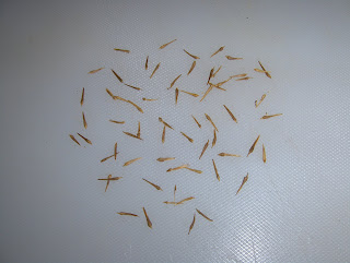 Lännenplataani - Sycamore, American Plane, Buttonwood (Platanus occidentalis)
 Lakkipuu - Kentucky Yellowwood (Cladrastis kentukea)
 Jumaltenpuu - Tree-of-heaven (Ailanthus altissima)
 Mantsurianvaahtera - Manchurian Maple (Acer mandschuricum)
 Huntuvaahtera - Three-flower Maple (Acer triflorum)
 Mustasaarni - Black Ash (Fraxinus nigra)
 Euroopanpyökki - European Beech (Fagus sylvatica)
 Punatammi - Red Oak (Quercus rubra)Tämän viikon keskiviikkona postitse saapui siemeniä, jotka tilasin aikaisemmin Arboretum Mustilalta. Ne ovat yllä kuvattuna eilen. Mittakaavan hahmottamiseksi mainitsen, että tämän alimman kuvan suurin siemen on pituudeltaan 2,2 cm ja kaikki kuvat on otettu n. 30 cm:n etäisyydeltä. Tilauksesta jäi saapumatta loppumisen takia kanukkalaji (Cornus kousa var. chinensis), puistoplataani (Platanus X acerifolia) ja loistokatsura (Cercidiphyllum magnificum). Eniten harmittaa tuon viimeisen lajin puuttuminen, koska viime keväänä sen lajin kylvös iti tosi kehnosti ja nekin vähäiset taimet kuolivat kesän mittaan. Eniten olen iloinen tuosta lakkipuusta. Sen siemeniä olen toivonut saavani jo monen monta vuotta ja nyt vihdoin niitä oli tarjolla. Kyseessä on todella aliarvostettu puu Suomessa, koska se on niin tuntematon huolimatta sen menestymisestä ja kauneudesta. Jumaltenpuuta minulla on muutama kappale taimistossa, mutta tilasin varmuuden vuoksi lisää.Tässä vaiheessa ei muuta arboretumasioista. Palaan siementen osalta asiaan, kun olen laittamassa lajeja esikäsittelyyn.At this week's wednesday via a post office there arrived seeds, which I ordered earlier from Arboretum Mustila. They are above as photographed yesterday. To be able to perceive the scale I mention, that the biggest seed in this lowest photo is 2,2 cm long and all photos are taken from the distance of about 30 cm.The seeds that didn't arrive with the order due to a shortage in stock include Chinese Flowering Dogwood (Cornus kousa var. chinensis), London Plane (Platanus X acerifolia) and Bigleafed Katsura Tree (Cercidiphyllum magnificum). I am annoyed the most about the lack of that last species, because last spring the sowing of that species germinated very badly and even those minor amounts of seedlings died during the summer.The most glad I am about that Kentucky Yellowwood. Its seeds I have been wishing to get for years and years and now finally they were at hand. The tree in question is really underrated in Finland, because it is so unknown despite its thriving and beauty. I have a few specimens of Tree-of-heaven at my nursery, but I ordered more to be sure.At this stage nothing more about the arboretum matters. I will return to the matter in the cases of seeds, when I am putting species into pretreatments.
Nyt on julkaistu Helsingin Puistolan syyskuun 2007 säätilasto. Siitä nähdään sen kuun jälleen kerran sattunut poikkeuksellinen lämpimyys. Tästä alkaa näemmä tulla normaalia :) Lämpimyyttä osoittavat yhtäältä minimilämpötilat. Niistä havaitaan, että pakkastilanteita oli vain yksi. Nollaa lähellä olleita hallatilanteita oli sen lisäksi muutamia, mutta vain lievinä. Puistolan sääasema on sen verran sisämaassa ja ilmeisesti hallanaralla paikalla, että siellä oli hallatilanteita enemmän kuin esim. taimistopaikallani. Toisaalta lämpimyyttä osoittavat vuorokauden keskilämpötilat (ja luonnollisesti myös maksimilämpötilat etenkin kuun lopulla). Nyt voimme havaita, että esim. tällä paikalla syksyn alkamisen määritelmä ei toteutunut missään vaiheessa; vähintään viisi peräkkäistä päivää alle +10 asteen keskilämpötiloja. Koko syyskuu oli näin ollen kesäkuukausi! Kuten muistamme, niin tämä kesä jatkui vielä lokakuunkin puolella ja viime "syksynä" oli sama tilanne. Lokakuun tilaston ilmestyttyä voimme tarkastella syksyn tarkkaa alkamispäivää tänä vuonna. Joka tapauksessa tämäkin vuosi näyttää nyt voimakkaan maistiaisen siitä, mihin ilmastonmuutos voi monen muun seikan lisäksi johtaa; vuodenaikojen tieteellinen määrittäminen menee kummalliseksi... Siitä kerroin esimerkkejä viime keväänäkin kasvukauden määrittämisen tapauksessa; tässä niistä yksi.Now the September 2007 weather chart of Puistola district in Helsinki has been published. From it we can see the once again happened unusual warmth of that month. It looks like this is going to be normal :) The warmth is pointed out in one hand by the minimum temperatures. From them we can observe, that there was only one frost situation. There were a few near zero C ground frost situations in addition to that, but only as minor. The Puistola weather station is so much in an inland area and apparently at a frost sensitive area, that there were more ground frost situations in there than for example at my nursery area.On the other hand the warmth is pointed out by the daily average temperatures (and naturally by the maximum temperatures especially at the end of the month). Now we can observe, that for example at this place the definition of the autumn's start didn't come true at any point; at least five days in a row average temperatures less than +10 C. Whole September was therefore a summer month! As we remember, this summer continued also in October and last "autumn" there was the same situation. As the chart of October will be published, then we can observe the precise starting day of the autumn this year. In any case this year as well is showing now a strong taster, of where the climate change may lead in addition to many other things; the scientific defining of the seasons will become peculiar... I told examples of that also last spring in the case of defining the growing season; here is one of them.


